 |
In 1070 B.C., Upper Nubia
would again become
independent and by 760 B.C. all of Nubia would be united under
King Kashta, from the first to the sixth cataract. This period
was known as the Napata period, as the Nubians took to burying
their Kings at the former Egyptian stronghold, taking it as
their own. The Nubians would go even further, in 743 B.C., the
Kushite King Piye invades Upper Egypt seizing control of it from
the Egyptians. His successor Shabaqo would establish the 25th
Pharaonic dynasty by uniting both Upper and Lower Egypt under
Kushite rule, establishing the Empire of Kush. However, about a
hundred years after its establishment, under Pharaoh Taharqo the
Empire intervened in the area of modern Syria in opposition to
the Assyrians. The Assyrians responded by invading Egypt and
driving the Nubian king out of Egypt and forcing him to withdraw
back to their homeland and return the dynasty to Napata |
|
In 590 B.C., they would again have to move
their capitol, when an Egyptian army sacked Napata. This time,
to the city of Meroe situated near the sixth cataract, well away
from northern aggression. Napata would still remain an important
religious center for the Nubians but the royal necropolis was
also moved to Meroe ushering in the Meroitic period of Nubian
history. For several centuries thereafter, the Kushite Kingdom
centered in Meroe developed independently of Egypt. While still
preserving the Pharaonic traditions like the raising of stelae
to record the achievements of their reigns and erecting pyramids
to contain their King's tombs.
The city of Meroe was ideally situation at the convergence of a
network of trade routes that ran along the White and Blue Niles.
Meroe became East Africa's most important center of trade. The
civilization thrived on trade with Egypt and the Greco-Roman
World, in addition to Arab and Indian traders along the Red Sea.
The Kushite Kings even managed to create an irrigation system
that was capable of supporting a higher population density
during this period then had been or would be possible in the
future. The Nubians also developed a new Meroitic script based
on the Egyptian writing system to better represent the
indigenous spoken language of its people. Despite mostly
peaceful relations with it neighbors, Nubian ambitions in Upper
Egypt provoked the Roman Army in 23 B.C. to move south against
them razing Napata to the ground. The Romans however abandoned
the area as being unfit for Roman colonization. During the 2nd
century A.D., a tribe known as the Nobatae that occupied the
Nile's west bank in Northern Kush integrated themselves first as
mercenaries then as a military aristocracy into the Meroitic
Kingdom. Introducing Camelry as a weapon of war into the Nubian
culture. However the fortunes of the Kushite Kingdom would come
to an end in the 4th century A.D., when it was overwhelmed by
the kingdom of Aksum that had developed in Abyssinia (or modern
Ethiopia) to the southeast.
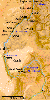
The site of Kerma, about 10 miles (16.5 km) south of the Third
Cataract, and about 350 miles (580 km) upstream (south) from
Aswan, is known to have been that of the largest city in the
Sudan during the period about 2000-1500 BC. Although we do not
yet know its ancient name, Kerma was the probable capital of the
first Nubian state to call itself Kush, and there is every
reason to believe that this phase was the latest of a major town
that had already existed here continuously for two or three
thousand years. This isolated but highly fertile region of the
Nile Valley, between Sai Island and the Fourth Cataract, was
uniquely suited for human settlement, independent cultural
evolution, and state formation. It was on a wide low-lying
plain, which the Nile irrigated with multiple channels, creating
many islands. In antiquity greater rainfall stimulated seasonal
growth of grasses in the plains and enabled the residents to
raise cattle on a grand scale. Whatever king could achieve
political power over this district could control all river
traffic between Egypt and the lands to the south - traffic from
which he could collect tolls, receive gifts, and amass great
wealth
In 1986 the expedition of the University of Geneva, Switzerland,
under the direction of Dr. Charles Bonnet, was excavating at the
ancient city site of Kerma, which dates to about 2500-1500 BC.
Beneath the cemetery of this city, about 1.5 mi (2.7 km) east of
the Nile, they found ruins of a second, older town, dating from
about 3500-2700 BC. This town is now called the "Pre-Kerma
settlement" and its culture the "Pre-Kerma." Mixed with these
remains were traces of an even older town, which have yielded
carbon dates stretching back to about 4800 BC.Between 1995 and
1998, 5000 sq. m. of the Pre-Kerma town were cleared, revealing
part of a complex plan including the remains of some 50 round
houses, which could be identified only by their surviving
patterns of post holes. The average house plan was just over 13
ft. (3-3.5 m) in diameter, but several were over 23 ft.(7-7.5 m)
in diameter, suggesting that they were used for important
community functions or were occupied by important persons. Such
houses are very similar to a type of rural African dwelling
still used in the Sudan. These are round, with conical roofs,
and were made of vertical posts and woven mats, sometimes
covered by layers of mud plaster. It was the vertical posts
whose holes survived in the ground. Some of the structures,
however, were only 3-4 ft. ( 1 - 1.3 m) in diameter, suggesting
their likely use as pens for young animals, such as one still
sees today in the Sudan.Two other buildings in the Pre-Kerma
town were rectangular in plan. Comparing these with seemingly
similar structures in use today by rural Sudanese nomads, we can
suggest that they might have been elevated platforms used to
store animal fodder.
There were also double lines of holes, suggesting where fences
had been built as animal corrals. The modern fences of the
Sudanese nomads are built in exactly the same way.Although no
imported Egyptian pottery or other material has yet been found
in the Pre-Kerma settlement, there seems little doubt that the
ivory and other African products found in contemporary Egyptian
sites were procured originally from the people of Upper Nubia.
Such goods would also have passed through the hands of the
A-Group Nubians. Rock drawings of very early ships of this
period have been found scratched in the boulders of the Second
and Third Cataracts, which would seem to prove that between 3500
and 2900 BC there was at least limited direct river traffic
between Egypt and the northernSudan. |