|
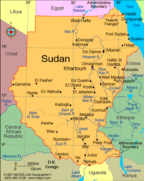
Sudan is the largest country in the continent of Africa
with an
area of almost a million (966,757) square miles, approximately
as large as the United States east of the Mississippi River. The
northern part of the country is a desert, with fertile lands
lying along the banks of the Nile River. Farther south is
savanna, or grasslands, with some low woodlands. The
southernmost part of the country includes wetlands, marshes, and
tropical woodlands. Only five percent of the land is considered
appropriate for farming, while forty-five percent is used for
grazing
 The population of Sudan was estimated at more than 34 million in
July 1999, with a growth rate of 2.7%. Forty-five percent of the
people are under age 15; only two percent are over 65. The
population is quite varied, composed of 19 major ethnic groups
(tribes) including almost 600 sub-groups speaking as many as 115
languages. In the north, most people speak Arabic; some of them,
like the Nubians, also speak a tribal language. In the north
people are Muslims, followers of the religion of Islam. In the
south, people primarily speak tribal languages; Arabic or
English is spoken as a second language. Many people in the south
are followers of traditional African religions; about five
percent are Christians. The population of Sudan was estimated at more than 34 million in
July 1999, with a growth rate of 2.7%. Forty-five percent of the
people are under age 15; only two percent are over 65. The
population is quite varied, composed of 19 major ethnic groups
(tribes) including almost 600 sub-groups speaking as many as 115
languages. In the north, most people speak Arabic; some of them,
like the Nubians, also speak a tribal language. In the north
people are Muslims, followers of the religion of Islam. In the
south, people primarily speak tribal languages; Arabic or
English is spoken as a second language. Many people in the south
are followers of traditional African religions; about five
percent are Christians.
Agriculture and cattle raising are the most important segments
of the Sudanese economy, employing 80% of the work force. People
raise wheat, sorghum, dates, and vegetables for food. They also
raise cattle, sheep, goats, and chickens. The nation's main
exports are cotton, gum arabic (a tree resin which is used in
making glue), livestock, sesame, and sorghum.
The Nile River, which runs through Sudan, is the longest river
in the world. Its main sources are two lakes. The Blue Nile,
which flows from Lake Tana in Ethiopia, is called "Blue" because
its waters, flowing rapidly down from the highlands of Ethiopia,
are clear and clean. The White Nile flows from Lake Victoria in
Uganda. It is called "White" because its waters, which flow
sluggishly across a relatively level plain with a great deal of
seasonal flooding, are full of silt; this gives them a milky
appearance. The White Nile and Blue Nile join, forming the Nile
River in Khartoum, the capital of Sudan. The Nile flows north
through Egypt and eventually empties into the Mediterranean Sea.
Khartoum and Omdurman
Khartoum is one of three sister cities, built at the convergence
of the Blue and White Niles: Omdurman to the north-west across
the White Nile, North Khartoum, and Khartoum itself on the
southern bank of the Blue Nile.
It was first established as a military outpost in 1821, and is
said to derive its name from the thin spit of land at the
convergence of the rivers, which resembles an elephant's trunk
(khurtum). Khartoum grew rapidly in prosperity during the boom
years of the slave trade, between 1825 and 1880. In 1834 it
became the capital of the Sudan, and many explorers from Europe
used it as a base for their African expeditions.
Khartoum was sacked twice during the latter half of the 19th
century -- once by the Mahdi and once by Kitchener when the
Mahdi was ousted. In 1898, Kitchener began to rebuild the city,
and designed the streets in the shape of the British flag, the
Union Jack, which he hoped would make it easier to defend. On
the opposite bank of the Nile, North Khartoum was developed as
an industrial area at about the same time.
Today's Khartoum is a quiet, unremarkable city. It has peaceful,
tree-lined streets, and in some ways still bears the
unmistakable mark of an outpost of the British Empire. Its
expansion to accommodate a rapidly-growing population, however,
has added very little in terms of charm or atmosphere.
Places to visit in Khartoum
National Museum. This contains antiquities and artefacts from
several periods of Sudanese history and pre-history, including
glassware, pottery, statuary and figurines from the ancient
kingdom of Cush. Ancient Nubia's Christian period is
well-represented, with frescoes and murals from ruined churches,
dating from the 8th to the 15th century. The Museum's garden
contains two reconstructed temples, which have been salvaged
from the Nubian land flooded by Lake Nasser. These Egyptian
temples of Buhen and Semna were originally built by Queen
Hatshepsut and Pharaoh Tuthmosis III respectively. The temples
have corrugated iron covers built over them to protect them from
humidity during the wet season. The original concept was to roll
back these covers during the dry season, but whether this ever
happened or not is unclear. The covers are rusted into place and
are now permanent and immovable!
Ethnographical Museum. This is a small museum which contains an
interesting collection of items relating to Sudanese village
life. These include musical instruments, clothing, cooking and
hunting implements.
Places to visit in Omdurman
Souq. This is the largest in the Sudan, and has an interesting
variety of goods on display. Ivory and ebony candlesticks are
carved by market craftsmen, goldsmiths and silversmiths fashion
all kinds of jewellery in their shop-fronts, and the atmosphere
is lively and bustling. The best time to visit is on Friday
mornings.
Camel Market. This is situated about 2km north of Omdurman's
main souq. Animals are mostly brought from eastern or western
areas of the Sudan.
Tomb of the Mahdi. On the death of the Mahdi in 1885, his body
was entombed in a silver-domed mosque in Omdurman. This was
completely destroyed by Kitchener in 1898, when the Mahdi's body
was burned and his ashes thrown into the river. In 1947 the
Mahdi's son had the mosque and tomb rebuilt. Not surprisingly,
it is closed to foreigners, but can be viewed from the outside.
Beit al-Khalifa. This is situated opposite the Mahdi's tomb.
Once the home of the Mahdi's successor, the house was built of
mud and brick in 1887, and is now a museum. It contains relics
from Mahdiyya battles, including guns, war banners and suits of
mail. An interesting collection of photographs depicts the city
of Khartoum at the time of the Mahdi's revolt and its subsequent
occupation by the British.
El-Obeid
This is the capital city of the Kordofan region in Western
Sudan, and was once the Mahdi's capital and political centre.
Situated in the middle of a vast stretch of barren desert, it
has a population of 200,000 people and is an important centre
for the production of gum arabic. This substance is used in the
manufacture of food thickening, ink and medicinal products, and
is obtained from acacia trees.
The city experiences problems with its supplies of both electric
power and water. Electricity from the city's own generators is
erratic and power cuts are the norm. In such an arid desert
environment, water supplies often dwindle and have to be brought
in by truck from other areas.
The two souqs in the city deal mostly in meat and vegetables.
There are also some tailor's shops where fabric can be purchased
and clothes made to order.
There is little to interest the visitor in El-Obeid, apart from
a small museum, which displays exhibits relating to ancient
Sudanese history. Its Catholic cathedral is impressive, however,
and is said to be one of the largest in Africa.
Port Sudan
Port Sudan is a harbour city,
established by the British in 1905
as a seaport. Once a thriving export centre handling the
country's raw commodities such as sesame, cotton and sorghum, it
has now fallen into decay as a result of the ongoing war.
Today's city is badly in need of care and repair, although it is
still possible to see beautiful lattice woodwork on the
window-screens of older buildings, which provide a glimpse into
the city's more prestigious past.
It was once possible to travel by boat from Port Sudan to Jeddah
in Saudi Arabia, but passenger traffic, like commercial
activity, has dwindled to the merest trickle. As a result,
passenger services from the port are no longer in existence.
For visitors interested in Red Sea diving, this is still quite a
good place to use as a base, and local hotels and dive shops can
make the necessary arrangements.
Kassala
Kassala is situated in Eastern Sudan and has a population of
150,000. The city is built on the Gash River and is the power
centre of one of the Sudan's traditional families -- the
Khatmiya Brotherhood, which opposed the Mahdi family in the last
century.
On the outskirts of the city live the Rashaida tribe, mostly
inhabiting goatskin tents. They are a nomadic people who breed
camels and goats, and are closely related to the Saudi Arabian
Bedouin, having migrated from the Arabian Peninsula about 150
years ago. It is the mysteriously-veiled Rashaida women who make
a great deal of the silver jewellery sold in the Kassala souq.
The souq is said to be one of Sudan's best, and sells a wide
variety of the fruit for which Kassala is renowned. Grapefruit,
pomegranates, oranges, bananas and melons are all for sale here,
as well as local handicrafts, fabrics and the aforementioned
silver jewellery.
Several kilometres outside Kassala are the curiously-shaped
'sugar-loaf' hills, known as the jebels. They can be seen on the
horizon from the city and are the habitat of a tribe of baboons,
which come down from the hills at sunset to drink at a nearby
village well.
Kassala is also a favourite retreat for Sudanese honeymoon
couples, and in the nearby village of Khatmiya, the same village
well is a traditional place for newly-wed couples to drink.
Water from the well is said to bring good luck and a fertile
married life.
Suakin Island
The island is situated 58km south of Port Sudan and was once a
major trading centre, particularly in the 19th century, during
the boom years of slavery. As far back as the 10th century BC,
Suakin was used by Pharaoh Rameses III as a trading port, but
declined in importance after the close of the 19th century AD,
and in 1905 was superseded in importance by Port Sudan.
Its unique architecture is made of coral, but these
once-beautiful buildings, although restored by the Mahdi in
1881, are now in the final stages of crumbling away. The island
is linked to the mainland by means of a causeway.
Dongola
Once an important centre of power in ancient Nubia, the remains
of the old northern-Sudanese city are being excavated by a
Polish-led team -- a project that has been in operation since
1964.
The town is now noteworthy for its palm groves and its September
date harvest, when young boys climb the palm trunks, carrying
sharp knives in their teeth, to cut the clusters of dates. The
fruit and vegetable souq here is a colourful sight, occasionally
dealing in camels, which the desert nomads bring in for sale.
The Cushite temple of Kawa is situated on the eastern bank of
the river. The ruins of this temple can be visited by taking a
ferry across the river from the main town.
Karima
This northern-Sudanese market town has a population of about
15,000. The town itself is of little interest, but there are
several ancient sites nearby which are worth a visit.
Just 2km south of the town is the 100-metre high Jebel Barkal, a
hill which was regarded as sacred by the Egyptians of the 18th
Dynasty. From its summit, there is an excellent view of the
Nile. At its foot lies the Temple of Amun, second only in length
to the famous Temple of Karnak. This was once surrounded by
about six smaller temples, and ruins of these, together with
statuary and hieroglyphics, make this an interesting Cushite
site.
Lying west of the temple are the Jebel Barkal Pyramids, similar
in style to those at Meroe.
Atbara
Located at the conjunction of the Atbara tributary, flowing down
from Ethiopia, and the River Nile, Atbara is on two main railway
routes: from Atbara to Port Sudan, and from Khartoum to Wadi
Halfa.
The city has a population of 75,000 people. In 1898 it was the
site of a battle between the British and the Mahdists, when
2,000 of the latter were wiped out by Kitchener. After the
battle, British officials settled here, building colonial-style
houses, which are now used as government offices.
The ruins of the Royal City of Meroe are located about 100km
south of Atbara. Residence of the kings of Meroe between 592BC
and AD350, the city shows strong Egyptian architectural
influence. The ruined Temple of Amun is still standing, together
with the remains several palaces and a swimming pool.
In the desert, about 5km to the east, stand the royal pyramids,
where the dead kings of Meroe are buried.
Jebel Marra Mountains
This western-Sudanese mountain range is dominated
by the
second-highest mountain in the Sudan, known as Jebel Marra. This
is an extinct volcano which rises to a height of 3071 metres.
At the base of the mountain range lies the town of Nyala, and
this town forms a good starting point for an exploration of the
surrounding mountainous countryside. It is a beautiful region of
hills, rivers and orchards, and is an interesting spot for
walking enthusiasts. There is a waterfall near the village of
Quaila and some hot springs near the crater of the volcano
itself.
El-Fasher
In the 18th century, El-Fasher was the main centre of the Fur
Sultanate. The sultan's palace can still be seen in this
western-Sudanese town, and is now a museum.
The town was also famous as the starting point of one of the
most important camel caravan routes in Africa. Known as the Darb
al-Arba'een, or Forty Days Road, this route carried ebony,
spices, rich cloth, ivory and slaves from all parts of Africa to
the Egyptian bazaars of Aswan and Asyut.
|